Page 1 of 1

GPS Geotagging options

PostPosted: Tue Apr 14, 2009 12:38 am
by tommyg
Heading overseas for a couple of months later in the year, and thinking of Geotagging all the photos in some way, but not sure of the best solutions.

We'll have 2 cameras - D90 and D700. So, would like a solution that covers both of these

Any thoughts greatly appreciated

Cheers
Tom

Re: GPS Geotagging options

PostPosted: Tue Apr 14, 2009 7:26 am
by ATJ
Tom,

I recommend you get a separate GPS logger (e.g. Holux M-241 GPS Logger) and then use something like Geosetter to tag the photos. As long as both cameras are in the vicinity of the logger, you'll be right.

Re: GPS Geotagging options

PostPosted: Tue Apr 14, 2009 7:59 am
by the foto fanatic
I recently bought a Solmeta Geotagger N2 direct from Hong Kong. It was a bit cheaper than the Nikon GP-1, and gives a "heading" reading that the Nikon does not. It's probably even cheaper now that the A$ has appreciated a tad.

It's relatively small, and just sits on the hot-shoe or neck strap. It embeds the GPS data in the Exif. If you use Lightroom, then with one click you are transported to a Google Map with a placemarker for your location.

I use it for my blog, where I provide a GPS reference for every post, and it works a treat.

Re: GPS Geotagging options

PostPosted: Wed Apr 22, 2009 11:18 pm
by latch
I wrote up my own experiences with getting into geotagging a little while back (mostly for my own reference, but hopefully useful to others at well), which you can read at http://lachlan.rogers.name/2009/02/fora ... ng-photos/

I should warn you, however, that geotagging can get a tad addictive :D

Re: GPS Geotagging options

PostPosted: Mon Jun 01, 2009 3:09 pm
by DaveB
FYI, I just posted an article that talks about getotagging within Lightroom.

Re: GPS Geotagging options

PostPosted: Mon Jun 01, 2009 4:16 pm
by tommyg
Thanks for the suggestions guys,

There're so many different GPS systems out there, all with their positives and negatives - makes it very hard to pick which way is best to go.

Cheers
Tom

Re: GPS Geotagging options

PostPosted: Tue Jun 02, 2009 12:46 pm
by stubbsy
DaveB wrote:FYI, I just posted an article that talks about getotagging within Lightroom.

I'd echo Dave's comments in his link regarding software to use if you have Lightroom in your workflow - Jeffrey Friedl's GPS plugin is dead easy to use and the price is right. As for hwardware - the reality is that as long as the data logger is compact with good storage and battery life then price should be the final determinant of what you purchase. For range have a look at Semson's in the US. I've bought from them in the past and their service is great.

Re: GPS Geotagging options

PostPosted: Tue Jun 02, 2009 2:01 pm
by ATJ
I personally don't like how the GPS plug-in for Lightroom works and will stick with using Geosetter. With Geosetter, the original NEF files don't have to be modified at all (it creates XMP sidecar files) but when I import the photos into Lightroom, the sidecars are read in and I get full GPS support within Lightroom and the GPS data is included in the exported files with no extra features required.

Re: GPS Geotagging options

PostPosted: Sun Oct 25, 2009 7:51 pm
by DaveB
I'm looking to get a new GPS logger. Preferably one that can run for >24 hours and then have a charged battery swapped into it. For example this can be left on the bridge of a ship continually logging positions (the GPS device I carry with me won't be able to see the satellites when I'm inside the steel ship) and I can clear it every day. BTW with two sets of logs (one for the ship and one for the logger I carry with me) I simply geocode with the "personal" data and then geocode with the "ship" data (only attaching it to images that didn't get a match already).

On the Antarctic trip we managed to get a log from the ship's navigator at the end of the trip, but there's no guarantee this can happen on every ship so I'm looking at my options for DIY.

The best candidate at the moment seems to be the Qstarz BT-1000. The battery is actually a Nokia BL-5C. The Holux m241 that's popular with some people here is only rated to run for ~12 hours, otherwise it might be good.
Does anyone here have experience with this or another suitable device?

ATJ wrote:I personally don't like how the GPS plug-in for Lightroom works and will stick with using Geosetter. With Geosetter, the original NEF files don't have to be modified at all (it creates XMP sidecar files) [...]

Sorry, I missed this comment back in June. The geocoding plug-in for LR doesn't modify NEF files either (it can rewrite XMP files). The major advantage for me of doing it from inside LR is that I don't need to have the GPS data in place to start working on and organising images. At the end of the day/week/whatever I can attach the GPS data to the images. Hopefully by then I will have noticed if I had the time wrong on any of my cameras (e.g. when on a trip traversing timezones) and fixed the times before geocoding.
Re: GPS Geotagging options

PostPosted: Sun Oct 25, 2009 9:02 pm
by Mr Darcy
The Holux can be powered via the USB port, so the battery life can be as long as you want it to be.
However, since I now run a Mac & I haven't found a good option for downloading track points on that system (I tried BT-&$& - it seemed to work for a while, then started randomly corrupting logs :(
I am now using a Garmin Oregon 300. This has the benefit of also working as a navigation system - though maps are an optional extra. It is dead easy to use. Again, battery life can be extended indefinitely using the USB port. Also you can drop in MicroSD cards to extend the track logs saved. It is a lot more expensive though. I have other uses for it that justify the expense.

Re: GPS Geotagging options

PostPosted: Sun Oct 25, 2009 10:13 pm
by aim54x
Nikon GP1/Phottix Geo One....simple plug into the camera and away you go. However you will pay a heavy price in terms of battery life. just another option, and both your bodies are compatible with these units.

Re: GPS Geotagging options

PostPosted: Mon Oct 26, 2009 12:42 am
by DaveB
Mr Darcy wrote:The Holux can be powered via the USB port, so the battery life can be as long as you want it to be.

Yeah, but I probably won't have the luxury of a spare USB (or AC for the adapter) port next to where the GPS has to go. Battery is the best option.

However, since I now run a Mac & I haven't found a good option for downloading track points on that system (I tried BT-&$& - it seemed to work for a while, then started randomly corrupting logs :(

Ouch, that's a concern. I was planning to use BT747 1.68.30. Maybe I need to be prepared to use the 2.x development version...

I am now using a Garmin Oregon 300. This has the benefit of also working as a navigation system - though maps are an optional extra. It is dead easy to use. Again, battery life can be extended indefinitely using the USB port. Also you can drop in MicroSD cards to extend the track logs saved. It is a lot more expensive though. I have other uses for it that justify the expense.

My other GPS (the one I carry with me) is a Garmin eTrex Legend HCx which has those advantages (and I think it's smaller than the Oregon). It's loaded up with basic maps for the world, and I could get another one, but the cost does not seem reasonable. A Qstarz BT-1000 with a spare battery (which I can charge externally) should only be <AU$140.


aim54x wrote:Nikon GP1/Phottix Geo One....simple plug into the camera and away you go. However you will pay a heavy price in terms of battery life. just another option, and both your bodies are compatible with these units.
Neither of my Canon DSLRs, nor my compact cameras are compatible with those units, and again if I happen to photograph inside (or just after I've come outside and before the GPS locks on) I wouldn't have a lock. I want a GPS logger so I can attach the location data to the photos irrespective of which camera was used.

Re: GPS Geotagging options

PostPosted: Mon Oct 26, 2009 7:52 am
by ATJ
I ran my Holux for 6 days on a dive trip I was on. As Greg says, it takes a USB input for power. I bought a Battery Bank 4 x AA USB A SKT with Switch Black from Jaycar and that would keep the logger going for more than 24 hours. All I had to do was change the batteries once per day.

I put the Holux in one ziplock bag and the battery bank in another ziplock bag and strapped them to a pole in the middle of the top deck of the boat with Velcro tape. While the pole was under cover, there was so much salt spray that the bags and tape were soaked most of the time. That didn't affect the batteries or the logger.

This is what I ended up with (click on it for a larger version):

Image

Re: GPS Geotagging options

PostPosted: Mon Oct 26, 2009 10:05 am
by Mr Darcy
Andrew, I get more than 12 hours on the Holux using a single Imedion in the unit.I would expect >24 Hours with the external battey pack. I don't use Bluetooth though. that may make the difference.

Dave, I haven't tried BT747 recently. It may work better now. Also the problem seemed to be specifically related to the Holux. If you use another unit, it may not be an issue.

Like Andrew I use GeoSetter. Great program. It is WIN only, so I run it on a Parallels VM (The Holux won't connect to the VM, so I can't run the native software for that in the VM)

I paid about $70 for the Holux when the $ was last high.

Re: GPS Geotagging options

PostPosted: Mon Oct 26, 2009 10:30 am
by aim54x
DaveB wrote:
aim54x wrote:Nikon GP1/Phottix Geo One....both your bodies are compatible with these units.
Neither of my Canon DSLRs, nor my compact cameras are compatible with those units, and again if I happen to photograph inside (or just after I've come outside and before the GPS locks on) I wouldn't have a lock. I want a GPS logger so I can attach the location data to the photos irrespective of which camera was used.

Dave my comment was intended for the original poster, tommyg who has a d90 and a d700. I am well aware that you are a canon user and that there units won't work for you. Please be aware that although there has been a divergence in the thread not everything is directed at your post.

Re: GPS Geotagging options

PostPosted: Mon Oct 26, 2009 10:34 am
by ATJ
Mr Darcy wrote:Andrew, I get more than 12 hours on the Holux using a single Imedion in the unit.I would expect >24 Hours with the external battey pack. I don't use Bluetooth though. that may make the difference.

Sorry, it was a typo on my behalf. I meant more than 24 hours. I did leave it running and I believe I got more than 36 hours but I can't remember exactly how long. Bottom line was I only had to change the batteries once per day (and I didn't make a typo there).

Re: GPS Geotagging options

PostPosted: Mon Oct 26, 2009 10:36 am
by ATJ
DaveB wrote:
ATJ wrote:I personally don't like how the GPS plug-in for Lightroom works and will stick with using Geosetter. With Geosetter, the original NEF files don't have to be modified at all (it creates XMP sidecar files) [...]

Sorry, I missed this comment back in June. The geocoding plug-in for LR doesn't modify NEF files either (it can rewrite XMP files). The major advantage for me of doing it from inside LR is that I don't need to have the GPS data in place to start working on and organising images. At the end of the day/week/whatever I can attach the GPS data to the images. Hopefully by then I will have noticed if I had the time wrong on any of my cameras (e.g. when on a trip traversing timezones) and fixed the times before geocoding.

Perhaps I have to revisit the options. The one I looked at definitely modified the NEFs and there was no option to change that. It also did silly things - I can't remember exactly what as it was 6 months ago.

Re: GPS Geotagging options

PostPosted: Mon Oct 26, 2009 11:56 am
by sirhc55

Re: GPS Geotagging options

PostPosted: Mon Oct 26, 2009 12:48 pm
by DaveB
Whoops - sorry Cameron!
:oops:

Re: GPS Geotagging options

PostPosted: Mon Oct 26, 2009 1:29 pm
by aim54x
DaveB wrote:Whoops - sorry Cameron!
:oops:


Its ok, I probably should have said my last post in a nicer tone...sorry if I have come off with a tone of aggression. PS where is a moderator when you need one...to split this thread into two.

Re: GPS Geotagging options

PostPosted: Mon Oct 26, 2009 4:03 pm
by DaveB
Good thought about the AA->USB power pack.
(that was a "Doh!" moment...)

Re: GPS Geotagging options

PostPosted: Tue Oct 27, 2009 10:04 am
by DaveB
Well, I pulled the trigger and ordered a Qstarz BT-1000. The longer battery life and newer GPS chipset were attractive, for about the same price as the Holux m241 (which does have a simple LCD, so I umm'ed and aah'ed for a while).
Hopefully I'll have enough time after it arrives to get it running smoothly in my setup before I get on the ship (I might end up tweaking the config while I'm in the UK on my way to Norway).

I'll let you know how it goes.

Re: GPS Geotagging options

PostPosted: Mon Nov 02, 2009 11:01 pm
by DaveB
DaveB wrote:Good thought about the AA->USB power pack.

I made this today. I went to a Sunday tech market but couldn't find anything appropriate, so made my own.

A 4xAA holder from DSE, a short USB cable, a knife, a soldering iron, heat-shrink tubing and a cable tie, and after 20 minutes I've got a compact and robust adapter that will supply 4.8-6V to a mini-A USB port. Cost: $2 (not counting my labour and the bits I had in the cupboard already).

Re: GPS Geotagging options

PostPosted: Mon Nov 09, 2009 9:48 pm
by DaveB
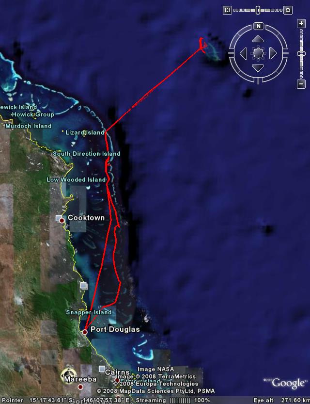
Got my Qstarz GPS logger on Saturday, tossed it in my luggage for an overnight trip to Sydney. Left it in my bag during the flight back, and now looking at it I have a nice track recording the flight path. It does seem a bit more resilient than my eTrex in getting and keeping a signal, even if the position jumps around a bit when I'm in buildings.

Using the BT747 software I just dump out a GPX file and then I can look at that in Google Earth and/or feed it into the photo geo-tagging software.
Happy camper!

Re: GPS Geotagging options

PostPosted: Tue Nov 10, 2009 1:12 pm
by muzz
Is anyone geotagging as part of an Aperture 2 workflow? I'd like to start doing this but not sure of the best options in terms of where in the workflow to do it.

Re: GPS Geotagging options

PostPosted: Tue Nov 10, 2009 10:46 pm
by DaveB
All I can suggest is to look at Maperture.

Re: GPS Geotagging options

PostPosted: Wed Nov 11, 2009 8:13 am
by photohiker
DaveB wrote:I'm looking to get a new GPS logger. Preferably one that can run for >24 hours and then have a charged battery swapped into it. For example this can be left on the bridge of a ship continually logging positions (the GPS device I carry with me won't be able to see the satellites when I'm inside the steel ship) and I can clear it every day. BTW with two sets of logs (one for the ship and one for the logger I carry with me) I simply geocode with the "personal" data and then geocode with the "ship" data (only attaching it to images that didn't get a match already).


I used a Garmin GPS60 on my Norway trip. I just parked it in the porthole of our cabin and it picked up the satellites fine.

You can probably get these reasonably cheaply on epay. They don't do mapping and the batteries last 24h+ We had 2 sets of batteries that cycled through the charger on a daily basis. Newer units like Mr Darcy's or my current Vista HCx take uSD cards and you can set them to make a daily tracklog which is quite convenient on multiday trips.

That said, I'd be surprised if you couldn't get a log from the bridge, they have a load of electronics up there, the massive navigation screens were awesome!

Michael

Re: GPS Geotagging options

PostPosted: Wed Nov 11, 2009 11:23 am
by DaveB
In January down south my Garmin eTrex Legend HCx (same as your Vista just without the altimeter/compass) often had satellite lock from inside our window, but sometimes not. There were quite a few gaps in the data. Last week I was expecting to have a staff cabin in the bowels of the ship, but now it seems I will probably have a cabin with a window. So the Qstarz in the cabin window may be fine (and that will be easy to set up with a continuous USB recharge). The eTrex will be in my pocket so I can check maps and our position without having to go back to the cabin (or to the TV screens around the ship that display a moving map) and be able to record where the camera was, in preference to having to fall back to where my cabin was when I took a picture.

I'll certainly be trying to make friends with the ship's navigator. If they can give me logs every couple of days that will be great, but I need to tread carefully to fit into the bridge protocols without complicating their lives.

Re: GPS Geotagging options

PostPosted: Wed Jan 06, 2010 11:09 am
by muzz
Hi Dave, just wondering how you are going with the Qstarz logger. I'm looking to buy a logger, either Holux, Qstarz or iBlue so wondering how your workflow with geotagging is going with the new unit.

Cheers, Muzz